
 Rafael Arce Nazario
cdfc370227
Actualizando con README de google docs e imagenes. Anadi preguntas diagnosticas.
Rafael Arce Nazario
cdfc370227
Actualizando con README de google docs e imagenes. Anadi preguntas diagnosticas.
|
10 vuotta sitten | |
|---|---|---|
| data | 10 vuotta sitten | |
| images | 10 vuotta sitten | |
| README.md | 10 vuotta sitten | |
| country.cpp | 10 vuotta sitten | |
| country.h | 10 vuotta sitten | |
| gispoi.cpp | 10 vuotta sitten | |
| gispoi.h | 10 vuotta sitten | |
| main.cpp | 10 vuotta sitten | |
| mainwindow.cpp | 10 vuotta sitten | |
| mainwindow.h | 10 vuotta sitten | |
| mainwindow.ui | 10 vuotta sitten | |
| map.cpp | 10 vuotta sitten | |
| map.h | 10 vuotta sitten | |
| prMap.pro | 10 vuotta sitten | |
| prmap.qrc | 10 vuotta sitten |
README.md
Arreglos de Objetos - PRMap
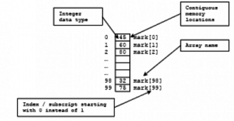
Los arreglos de datos (arrays) nos facilitan guardar y trabajar con grupos de datos del mismo tipo. Los datos se guardan en espacios de memoria consecutivos a los que se puede acceder utilizando el nombre del arreglo e índices o suscritos que indican la posición en que se encuentra el dato. Las estructuras de repetición nos proveen una manera simple de acceder a los datos de un arreglo.
Un objeto es una entidad que se utiliza en muchos lenguajes de programación para integrar los datos y el código que opera en ellos, haciendo más fácil el modificar programas grandes. Una tarea bien común en programación usando C++ lo es el trabajar con arreglos de objetos. En la experiencia de laboratorio de hoy estarás trabajando con datos “georeferenciados” de pueblos en Puerto Rico, en donde tendrás atributos, como el nombre del pueblo, la latitud y longitud de su localización, que utilizarás para ilustrar propiedades en un mapa.
Objetivos:
Crear dinámicamente y manipular un arreglo de objetos.
Codificar funciones para procesar arreglos de objetos.
Practicar el pasar arreglos de objetos como parámetros de una función.
Practicar la lectura secuencial de datos en un archivo.
Usar programación modular.
Usar estructuras de repetición y control.
Pre-Lab:
Antes de llegar al laboratorio debes haber:
Repasado los conceptos relacionados a arreglos de objetos.
Repasado los conceptos relacionados funciones que utilizan arreglos de objetos.
Repasado cómo leer datos de un archivo.
Estudiado los conceptos e instrucciones para la sesión de laboratorio.
Tomado el quiz Pre-Lab que se encuentra en Moodle.
Datos “georeferenciados”
Trabajar con arreglos de objetos es una tarea bien común en la programación usando C++. Una vez has leido la información de los objetos de un archivo o provenientes de un usuario, debes depender de tus destrezas algorítmicas y conocimiento sobre C++ para invocar los métodos y funciones adecuadas para procesar los datos correctamente.
En esta experiencia de laboratorio estarás trabajando con datos “georeferenciados” sobre las ciudades en Puerto Rico. El que un dato sea “georeferenciado” quiere decir que el dato tiene una localización física asociada. Típicamente, esta localización son coordenadas de longitud y latitud. Por ejemplo, lo que sigue es parte de un archivo que contiene datos georeferenciados de pueblos en Puerto Rico:
Arroyo 17.9658 -66.0614
Bayamon 18.3833 -66.15
Caguas 18.2342 -66.0486
Dorado 18.4589 -66.2678
Fajardo 18.3258 -65.6525
Figura 1. Parte del contenido de una archivo de datos georeferenciados de pueblos en Puerto Rico; contiene nombre del pueblo, coordenadas de latitud y coordenada de longitud.
Distancia ortodrómica
Para calcular la distancia entre dos puntos en el plano Euclideano, trazas el segmento de línea recta que une a los puntos y calculas su largo utilizando la fórmula de distancia que estudiaste en tu curso de Pre-cálculo. Para calcular la distancia entre dos puntos en la superficie de una esfera no utilzas el segmento de línea que los une, utilizas la distancia más corta entre esos puntos medida sobre la esfera. Esta distancia se llama distancia ortodrómica. Para calcular la distancia ortodrómica entre dos puntos en el globo terráqueo se usan las coordenadas de latitud y longitud.
La clase GPOI
La manera más común para los programadores en C++ encapsular datos asociados a un ente es utilizando clases. Por ejemplo, en el caso de datos georeferenciados, una manera práctica de encapsular la información para cada pueblo sería implementando una clase GeoreferencedPointOfInterest que contenga al menos datos (o atributos) para: el nombre del pueblo, su latitud y su longitud. La clase GPOI también necesitará implementar métodos para acceder, modificar y hacer operaciones en sus atributos.
En esta experiencia de laboratorio te proveemos una clase GPOI con los siguientes métodos de interfase:
GISPOI(): constructor por defectoGISPOI(QString s, double latitude, double longitude): constructor que recibe nombre, longitud y latituddouble getLat(),double getLon(): “getters” para la latitud y longitudQString getName(): “getter” para el nombrevoid setAll(string s, double a, double b): “setter” para todas las propiedades (a la vez)double odDistance(const GISPOI &B) const: dado otro objetoBde la claseGPOI, devuelve la distancia ortodrómica (orthodromic) (la distancia más corta) entre elGPOIque invoca yB
!INCLUDE “../../eip-diagnostic/PRMap/es/diag-prmap-01.html”
!INCLUDE “../../eip-diagnostic/PRMap/es/diag-prmap-02.html”
!INCLUDE “../../eip-diagnostic/PRMap/es/diag-prmap-03.html”
Sesión de laboratorio:
Ejercicio 0 - Bajar y entender el código
Instrucciones
Carga a QtCreator el proyecto
prMaphaciendo doble “click” en el archivoprMap.proen el directorioDocuments/eip/ObjectsArrays-PRMapde tu computadora. También puedes ir ahttp://bitbucket.org/eip-uprrp/objectsarrays-prmappara descargar la carpetaObjectsArrays-PRMapa tu computadora.Compila y corre el programa. En su estado actual, el programa solo despliega un mapa de Puerto Rico. En este mapa podrás ver los resultados de tu programa. Quizás ves algunas advertencias (“warnings”) debido a que hay algunas funciones que están incompletas. Estarás completando estas funciones durante la experiencia de laboratorio.
Abre el archivo
main.cpp. En este archivo es que estarás escribiendo tu código. El archivo contiene las siguientes funciones:void printArrayOfCities(GISPOI A[], int size): Dado un arregloAde objetos de la claseGISPOIy su tamaño, imprime todos los pueblos en el arreglo. Puedes usar esta función como parte de tu proceso de depuración (“debugging”).int countLinesInFile(ifstream &file): Dada una referencia a un objeto que representa un archivo, esta función cuenta y devuelve el número de filas del archivo.void readFileToArray(ifstream &file, GISPOI A[], int numOfCities): Dado el objetoifstreamde un archivo, un arreglo de pueblos, y el número de registros para leer del archivo, esta función lee los valores del archivo y llena el arreglo con objetos. Esta es una función que tú implementarás.void maxDistances(GISPOI A[], int size, int &idxCityA, int &idxCityB): Dado un arregloAde pueblos, determina los dos pueblos que quedan más lejos. Recuerda que la distancia que calcularás será la distancia ortodrómica. La función devuelve (por referencia) los índices de estas ciudades en el arreglo. Esta es una función que tú implementarás.void minDistances(GISPOI A[], int size, int &idxCityA, int &idxCityB): Dado un arregloAde pueblos, determina los dos pueblos que quedan más cerca. Recuerda que la distancia que calcularás será la distancia ortodrómica. La función devuelve (por referencia) los índices de estas ciudades en el arreglo. Esta es una función que tú implementarás.double cycleDistance(GISPOI A[], int size, int P[]): Dado un arregloAde pueblos, el tamaño de este arreglo, y un arregloPcon una permutación de los enteros en[0,size-1], computa y devuelve la distancia de viajar el ciclo de pueblosA[P[0]]$$\rightarrow$$A[P[1]]$$\rightarrow \cdots \rightarrow$$A[P[size-1]]. Recuerda que la distancia que calcularás será la distancia ortodrómica.Por ejemplo, si los pueblos que se leen del archivo fueran Mayaguez, Ponce, Yauco y San Juan (en ese orden) y la permutación
Pes $$(3, 1, 0, 2$$, la función debe computar la distancia del ciclo San Juan $$\rightarrow$$ Ponce $$\rightarrow$$ Mayaguez $$\rightarrow$$ Yauco $$\rightarrow$$ San Juan.Esta es una función que tú implementarás.
Hay otras dos funciones que debes conocer:
void MainWindow::drawLine(const GISPOI &city01, const GISPOI &city02): Dada una referencia a dos objetosGISPOI, la función pinta una línea entre ellos.void drawPoints(GISPOI* gisLocations, unsigned int size);: Dado un arreglo de objetosGISPOIy su tamaño, despliega sus localizaciones como puntos en el mapa.
Ejercicio 1 - Leer los puntos georeferenciados a un arreglo
Recuerda que solo estarás cambiando código en el archivo main.cpp. Tu primera tarea será añadir código para leer todo el contenido de un archivo a un arreglo de objetos GISPOI.
En la función
main(), añade las instrucciones necesarias para abrir el archivo que contiene la información de los pueblos georeferenciados. El archivo que usarás primero está en el directoriodatay espr10.txt. Necesitas dar elpathcompleto del archivo como parámetro del métodoopen()de tu objetoifstream. Como siempre, cuando uses archivos debes verificar si el nombre del archivo que pusiste se puede abrir para leer exitosamente.Invoca la función
int countLinesInFile(ifstream &inFile)para obtener el número de líneas en el archivo. Puedes imprimir el número de líneas obtenido de modo que valides que tu programa está funcionando correctamente.Crea un arreglo dinámicamente tan grande como el número de líneas en tu programa.
Modifica la función
void readFileToArray(ifstream &file, GISPOI A[], int numOfCities)de modo que lea todas las líneas en el archivo a los objetos en el arreglo.En la función
main(), invoca la funciónreadFileToArray, pasando la referencia al archivo, el arreglo que creaste en el paso 3, y su tamaño.Luego de invocar la función
readFileToArraypuedes invocar la funciónvoid printArrayOfCities(GISPOI A[], int size)para imprimir los nombres y georeferencias de los puntos leidos del archivo.Invoca el método
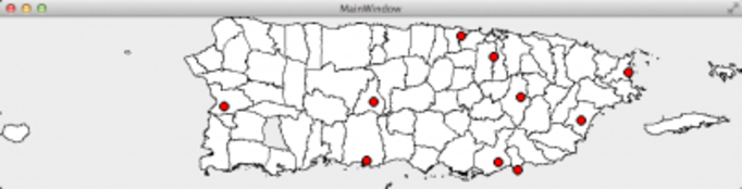
drawPoints(GISPOI* gisLocations, unsigned int size)en el objetowde modo que se muestre un punto en el mapa para cada pueblo. La invocación debe hacerse de esta manera:w.drawPoints(A, size)(asumiendo queAes el nombre de tu arreglo). Debes obtener algo parecido a la siguiente figura:
Ejercicio 2 - Funciones max y min
Una vez que tengas la información de los pueblos georeferenciados en el arreglo de objetos, puedes comenzar a procesarlos de muchas formas interesantes. Comenzaremos con algunas operaciones básicas.
Lee la documentación e implementa la la función
void maxDistances(GISPOI A[], int size, int &idxCityA, int &idxCityB). Invoca la función desdemain().Usa el método
void drawLine(const GISPOI &city01, const GISPOI &city02)del objetowpara dibujar una línea que conecte los pueblos más lejanos. Nota que el segundo y tercer parámetro de este método son referencias a los objetos que representan los pueblos (no sus índices en el arreglo).Lee la documentación e implementa la función
void minDistances(GISPOI A[], int size, int &idxCityA, int &idxCityB). Invoca la función desdemain().Usa el método
void drawLine(const GISPOI &city01, const GISPOI &city02)del objetowpara dibujar una línea que conecte los pueblos más cercanos.
Ejercicio 3 - Computa la distancia del ciclo
Lee la documentación e implementa la función
double cycleDistance(GISPOI A[], int size, int P[]). Invoca la función desdemain()como se indica en los comentarios dentro de la funciónmain():- Primero con $$P =(0, 2, 4, 6, 8, 1, 3, 5, 7, 9)$$,
- Luego con = $$P=(0, 3, 6, 9, 1, 4, 7, 2, 5, 8)$$.
Ejercicio 4 - ¡Más diversión!
Cambia tu código de modo que ahora abra el archivo pr.txt. Valida tus resultados y ¡maravíllate de tu gran logro!
Entrega
Utiliza “Entrega” en Moodle para entregar el archivo main.cpp. Recuerda utilizar buenas prácticas de programación, incluir el nombre de los programadores y documentar tu programa.
Referencias
[1] https://en.wikipedia.org/wiki/Great-circle_distance
Arrays of Objects - PRMap
Arrays help us to store and work with groups of data of the same type. The data is stored in consecutive memory spaces which can be accessed by using the name of the array and indexes or subscripts that indicate the position where the data is stored. Repetition structures provide us a simple way of accessing the data within an array.
An object is an entity that it is used in many programming languages to integrate the data and the code that operates on it, simplifying the modification of large programs. A common task in programming using C++ is working with arrays of objects. In today’s laboratory experience you will be working with georeferenced data of cities in Puerto Rico, where you will have attributes, such as name of the city, the latitude and longitude of its location, that you will use to illustrate properties in a map.
Objectives:
Dynamically create and manipulate an array of objects.
Code functions that process arrays of objects.
Practice passing arrays of objects as parameters in a function.
Practice the sequential reading of data from a file.
Use modular programming.
Use repetition and decision structures.
Pre-Lab:
Before coming to the laboratory you should have:
Reviewed the concepts related to arrays of objects.
Reviewed the concepts related to functions that use arrays of objects.
Reviewed how to read data from a file.
Studied the concepts and instructions for the laboratory session.
Taken the Pre-Lab quiz that can be found in Moodle.
Georeferenced Data
Working with arrays of objects is a very common task in programming with C++. Once you have read the object’s information from a file or as user input, you should use your algorithmic skills and knowledge of C++ to invoke the adequate methods and functions to process the data correctly.
In this laboratory experience, you will be working with georeferenced data about the cities in Puerto Rico. When a data is georeferenced it simply means that it has an associated location in physical space. Typically this location are latitude and longitude coordinates. For example, the following is part of a file that contains georeferenced data for some Puerto Rican cities:
Arroyo 17.9658 -66.0614
Bayamon 18.3833 -66.15
Caguas 18.2342 -66.0486
Dorado 18.4589 -66.2678
Fajardo 18.3258 -65.6525
Figure 1. Part of the content of a file with georeferenced data of cities in Puerto Rico; contains name of the city, coordinates for latitude and longitude.
Orthodromic Distance
To calculate the distance between two points in the Euclidean plane, you trace the straight line segment that joins the points and compute its length using the distance formula you studied in your Pre-Calculus course. To calculate the distance between two points in the surface of a sphere you don’t use the straight line segment that joins them, you use the shortest distance between these points measured over the sphere. This distance is called the orthodromic distance. To calculate the orthodromic distance between two points in the earth globe, the latitude and longitude coordinates are used.
The GPOI Class
The most common way for C++ programmers to encapsulate data to an entity is by using classes. For example, in the case of the georeferenced data, a practical way to encapsulate the information about each city would be to implement a GeoreferencedPointOfInterest class that contains at least data members (or attributes) for: the name of the city, its latitude and longitude. The GPOI class would also need to implement methods to access, modify, and perform computations on its attributes.
In this laboratory experience, you are provided a GPOI class with the following interface methods:
GISPOI(): the default constructorGISPOI(QString s, double latitude, double longitude): constructor that receives name, longitude and latitude.double getLat(),double getLon(): getters for the latitude, longitude.QString getName(): getter for the name.void setAll(string s, double a, double b): setter for all the properties (at once)double odDistance(const GISPOI &B) const: givenB, anotherGPOIobject, returns the orthodromic distance (or the closest distance) between the invokingGPOIandB.
!INCLUDE “../../eip-diagnostic/PRMap/en/diag-prmap-01.html”
!INCLUDE “../../eip-diagnostic/PRMap/en/diag-prmap-02.html”
!INCLUDE “../../eip-diagnostic/PRMap/en/diag-prmap-03.html”
Laboratory Session:
Exercise 0 - Download and understand the code
Instructions
Load the
prMapproject onto Qt by double clicking on theprMap.profilein the directoryDocuments/eip/Arrays-PRMapof your computer. You may also go tohttp://bitbucket.org/eip-uprrp/objectsarrays-prmapto download theObjectsArrays-PRMapfolder to your computer.Build and run the program. In its current state, the program simply displays a map of Puerto Rico. This map is provided so that you can visualize the results of your program. You may see some warnings which are due to the fact that some of the functions are incomplete. You will complete them throughout this laboratory experience.
Open the
main.cppfile. This is the file where you will be writing your code. This file contains the following functions:void printArrayOfCities(GISPOI A[], int size): GivenA, an array ofGISPOIobjects and its size, prints all the cities in the array. You may use this function as part of your debugging process.int countLinesInFile(ifstream &file): Given a reference to the object that represents a file, this function counts and returns the number of lines in the file.void readFileToArray(ifstream &file, GISPOI A[], int numOfCities): Given theifstreamobject of a file, an array of cities and the number of records to read from the file, this function reads the values from the file and populates the array with objects. This is a function you will implement.void maxDistances(GISPOI A[], int size, int &idxCityA, int &idxCityB): GivenA, an array of cities, determines the farthest two cities. Remember that the distance you will calculate is the orthodromic distance. The function returns (by reference) the indices of these cities in the array. This is a function you will implement.void minDistances(GISPOI A[], int size, int &idxCityA, int &idxCityB): GivenA, an array of cities, determines the closest two cities. Remember that the distance you will compute is the orthodromic distance. The function returns (by reference) the indices of these cities in the array. This is a function you will implement.double cycleDistance(GISPOI A[], int size, int P[]): Given an array of citiesA, the size of the array, and an arrayPwith a permutation of the integers in[0, size-1], computes and returns the distance to travel the cycle of citiesA[P[0]]$$\rightarrow$$A[P[1]]$$\rightarrow \cdots \rightarrow$$A[P[size-1]]. Remember that the distance you will calculate is the orthodromic distance.For example, if the cities read from the file where Mayaguez, Ponce, Yauco and San Juan (in that order) and the permutation
Pis $$(3, 1, 0, 2$$, the function should compute the distance of a cycle from San Juan $$\rightarrow$$ Ponce $$\rightarrow$$ Mayaguez $$\rightarrow$$ Yauco $$\rightarrow$$ San Juan. This is a function you will implement.
There are two additional functions that you need to know:
void MainWindow::drawLine(const GISPOI &city01, const GISPOI &city02): Given a reference to twoGISPOIobjects, the function draws a line between them.void drawPoints(GISPOI* gisLocations, unsigned int size);: Given an array ofGISPOIobjects and their size, displays their locations as points in the map.
Exercise 1 - Read the georeferenced points into an array
Remember that you will only be changing code in the main.cpp file. Your first task will be to add code to read the entire contents of a file into an array of GISPOI objects.
In the
main()function, add the necessary instructions to open the file that contains the georeferenced city information. The file that you will use first ispr10.txtand it is in thedatadirectory. You need to provide the completepathto the file as a parameter to theopen()method of yourifstreamobject. As always, when using files you should verify if the entered name is a file that can be successfully opened for reading.Invoke the
int countLinesInFile(ifstream &inFile)function to obtain the number of lines in the file. You may print out the number obtained so that you can validate is your program is working correctly.Dynamically create an array as big as the number of lines in the file.
Modify the
void readFileToArray(ifstream &file, GISPOI A[], int numOfCities)function so that it reads all the lines in the file to the objects in the array.In the
main()function invoke thereadFileToArrayfunction, passing the reference to the file, the array you created in step 3, and its size.After invoking
readFileToArrayyou may invokevoid printArrayOfCities(GISPOI A[], int size)to print the names and georeferences of the points read from the file.Invoke the method
drawPoints(GISPOI* gisLocations, unsigned int size)on thewobject so that a point will be shown in the map for each city:w.drawPoints(A, size)(assuming thatAis the name of your array). You should obtain something similar to the next figure.
Exercise 2 - Max and min functions
Once you have the information of georeferenced cities in the array of objects, you can start processing them in many interesting ways. We will start with some basic operations.
Read the documentation and implement the function
void maxDistances(GISPOI A[], int size, int &idxCityA, int &idxCityB). Invoke the function frommain().Use the
void drawLine(const GISPOI &city01, const GISPOI &city02)method of thewobject to draw a line connecting the two farthest cities. Notice that the second and third parameters of this method are ** references to the objects that represent the cities** (not their indices in the array).Read the documentation and implement the function
void minDistances(GISPOI A[], int size, int &idxCityA, int &idxCityB). Invoke the function frommain().Use the
void drawLine(const GISPOI &city01, const GISPOI &city02)method of thewobject to draw a line connecting the two closest cities.
Exercise 3 - Compute the cycle distance
Read the documentation and implement the function
double cycleDistance(GISPOI A[], int size, int P[]). Invoke the function frommain()as indicated in the comments inside themain()function:- First with $$P = (0, 2, 4, 6, 8, 1, 3, 5, 7, 9)$$
- Then with $$P =(0, 3, 6, 9, 1, 4, 7, 2, 5, 8)$$
Exercise 4 - More fun!
- Change your code so that it now opens the
pr.txtfile. Validate your results and wonder at your great achievement!
Deliverables
Use “Deliverables” in Moodle to hand in the main.cpp file. Remember to use good programming techniques, include the name of the programmers involved, and document your program.